Himalayan Balsam: 2021
All Clear ????
General: Work covers some 18 acres of wetland and adjacent areas that stretch some 1.1Km along the river. Areas are labelled {1,2,3 and 4} and are numbered from, north to south (1&2), south-west (3) and west (4)
Area 1

Area 1 is partitioned as follows:
- yellow Part of the top field east to the drainage channel of the lower field.
- green This is the lower field, between west, south and east drainage channels.
- blue The line indicates the western edge of the bund.
- orange Area 2
Diary
- October 6th
Area 1 yellow : 8 In the same area as 11th Sept - September 15th
Area 1 yellow : 8 In the same area as 11th
Area 1 green : 5 towards the outer drain by the big willow. - September 12th
Area 1 yellow : 18 In the same area as yesterday but a few stretching down to the drain to the east
Area 1 blue : 2 Riverside by the big oak - September 11th
Area 1 yellow : 97 37 in small in a patch mentioned on 10th August and 60 a few metres to the north east - August 24th
Area 1 blue : 3 2 in the neighbours field 1 nearby
Area 1 green : 2 towards the outer drain by the big willow.
Area 1 yellow : 165 2 by the dead pine tree and the other 163 by the 120 found on August 10th. - August 10th
Area 1 green : 30 some 45m from the south alongside the drain. - August 10th
Area 1 yellow : 120 Mostly small in a patch some 6m² in the south east, before it narrows, maybe from a lone plant missed last year, or deer trash etc. - August 4th
Area 1 green : 28 some 60m from the south alongside the drain.
There are few more but I tripped and lost my glasses then stepped on them whilst trying to find them. Luckily Tuai turn up and found them, but that put an end to the day - July 23rd
Area 1 green : 27 some 60m from the south alongside the drain - July 18th
Area 1 blue : 14 6 riverside mid the row of trees on the bund to the south and 8 riverside under the oak
Area 2
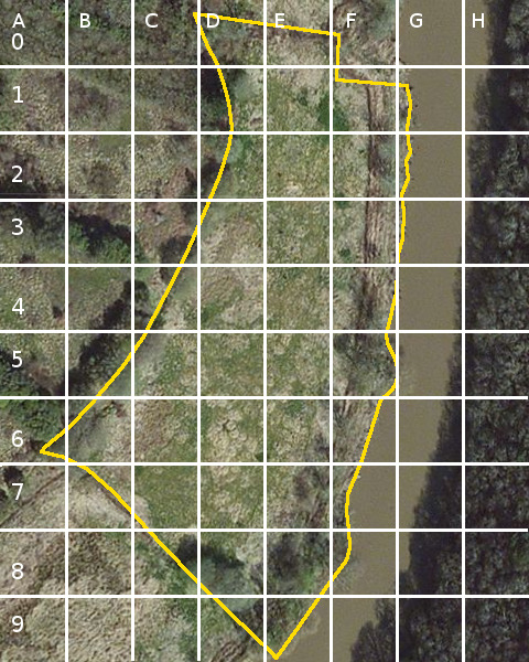
Reason for the grid
Area 2 covers three major problems, which may not be the last, namely
- The large patch of Japanese Knotweed (E8)
- The failure of the bund by the Japanese Knotweed (E9)
- A major break in the bund (F3/F4)
The southern end of Area2 is 35m from the drain that separates the lower fields Area2 and Area3 or 25m from the damaged bund drain.
Diary
- September 12th 9 2 @ D0 :: 3 @ F4 and 2 @ F1Found my glasses, slightly damaged
- September 11th 6 5 E6 and 1 in E4 Found my glasses, slightly damaged
- September 11th 12 2 in F8 and 10 in F6 and I lost my glasses in E6 trying to get one plant.
- August 24th 26 5 in E6, 5 in E5, 9 in F3 and 7 in F4
- August 23rd 15 1 in E9 and 14 in D8
- August 4th 245
2 at E8 on the field side of the drain. 7 further north and 15 on the south east of the breach. F4 - July 18th 16 D1 The north west corner.
- July 18th 19 4 at F3 the bund side of the drain and 15 at G6 on the riverside by the felled pair of trees.
- July 15th 11 E8 on the field side of the drain.
- May 20th 4 E8 on the riparian south side of the bund.
- June 3rd 3 E8 on the riparian south side of the bund.
- May 14th 4 E8 on the riparian south side of the bund.
- Apr 29th 1 E8 on the riparian south side of the bund.
Area 3

- September 11th 16 12 In the east corner just off the drain going NW~SE 4 river edge just south of large felled willow
- August 23rd 11 In the east corner just off the drain going NW~SE
- August 4th 41 35 In the east corner just off the drain going NW~SE and 7 some 70 to 80 metres west adjacent the drain.
- July 15th 48 34 In the east corner just off the drain going NW~SE and 14 some 70 to 80 metres west adjacent the drain.
- July 15th 68 In the east corner just off the drain going NW~SE
Area 4
is 7 acres of reed bed and carr that stretches west from the boat.
Area 5
is the small triangle field