Himalayan Balsam: 2023
General: Work covers some 18 acres of wetland and adjacent areas that stretch some 1.1Km along the river. Areas are labelled {1,2,3 and 4} and are numbered from, north to south (1&2), south-west (3) and west (4)
Area 1

Area 1 is partitioned as follows:
- [A] yellow Part of the top field east to the drainage channel of the lower field. Update map to include strip alongside Trekensa
- [B] green This is the lower field, between west, south and east drainage channels.
- [C] blue The line indicates the western edge of the bund.
- [D] orange Area 2
Diary
- October 29th: 1A 0 Only checked the patch on the slop to the drain
- September 27th: 1A 73 around new patch 4 further north by the drain and 4 alongside Trekensa: Then 31 from Trekensa and 1 by the adjacent drain
- September 9th: 1A 2214 around new patch 4 further north and by the drain (see July 26th) and 4 alongside Trekensa: Then 31 from Trekensa and 1 by the adjacent drain
- August 23rd: 1A 6315 around new patch and 16 alongside Trekensa: Then 31 from Trekensa and 1 by the adjacent drain
- August 22nd: 1A Just off the path, maybe a quarter of the way down from the north west
- st 3rd: 1A 2214 around the 'new' patch and 8 along the boundary with Trekensa
- July 26th: 1A 37north of the 'new' patch and down by the drain. Huge clearly a missed bunch
- July 6th: 1A 27 9 from the 'new' patch and down to the drain and a bit north and 20 adjacent Trekensa
- June 15th: 1A 190 Half from the 'new' patch and down to the drain and a bit north and half along the wall to the south adjacent Trekensa
Area 2
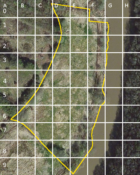
Reason for the grid
Area 2 covers three major problems, which may not be the last, namely- The large patch of Japanese Knotweed (E8)
- The failure of the bund by the Japanese Knotweed (E9)
- A major break in the bund (F3/F4)
The southern end of Area2 is 35m from the drain that separates the lower fields Area2 and Area3 or 25m from the damaged bund drain.
Diary
- August 22nd ? @ E8 and 1 @ F4
- June 26th 3 @ F3 and 2 @ F2
- June 14th None
Further areas sections hidden as no sightings for some three years